The
Fanes' places: mount Amariana
It
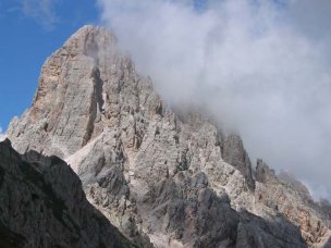
probably was the Croda
da Lago ("Lake's Peak") (cima
Ambrizzola, m 2715). The slim, elegant
structure stands out lonely, due South of the ancient sacred
lake situated at the source of the ru
de ras Virgines, (Virgins' Brook), connected with the Sun
myth of Merisana's
wedding with the "king of rays". The Ambrizzola
Top is the highest and southernmost of
the group.
Climbed
for the first time
(Ey-de-Net apart!) by Fröschels, Silverstein,
A. and P. Dimai in 1878, through the normal route.
The
group, consisting of Norian
Main
dolomite, stands over a bank of Carnian
dolomite, that composes its whole pedestal, as
well as the Lastoni di Formin.
The
reasons why I believe that cima Ambrizzola is the most
probable localization of mount Amariana, that Ey-de-Net
climbs "before sunrise, to greet the rising Sun from its
top" just before the battle at Fiammes,
are detailed in >Essays >
mount Amariana.
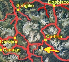
| Well
visible from: Cortina d'Ampezzo basin,
Tofane, Nuvolau, Mondeval
plateau...
|
|
| |
| Climbs:
normal route (east face), from the Ambrizzola
saddle, through talus, ledges and gullies, 1st gr (2.5
hs). The Croda da Lago group presents a large
number of other alpinistic routes of various difficulties,
some of which have entered in their own good right into
the history of rock climbing.
|
|
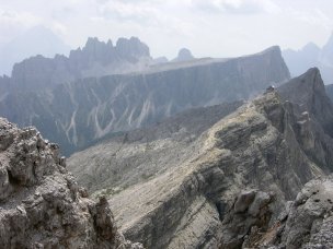
The toothed profile of the Croda da Lago seen
from the Averau cliffs; in between, the peculiar
incline of the Lastoni di Formin
(photo Max - http://www.cemax.it)
|
| |
|
Excursions:
round
trip
starting from Giau pass m 2236: to Giau
saddle m 2360 (1h); through the Mondeval
plateau to Ambrizzola saddle m 2277(1 h); from
here to the Palmieri hut m 2046 (1/2 hs.); to
the Rucurto bridge m 1708 (1 h); from here back
to Giau pass, partially on car road (1 1/4 hs).
Alternative: from the Palmieri hut, down to the
Casoni di Formin m 1850, then turn left and climb
the Formin valley across the Lastoni
stone field up to the Rossa del Formin saddle
(or Lastoni saddle) m 2462 (2 hs.); from here,
through the
Mondeval,
reconnect with the first part of the itinerary, to be
walked back.
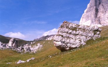
The
Mondeval
plateau is famous for the burial of a Mesolithic
hunter who lived 7,000 years ago [who,
then, has nothing to share with the Fanes
or the Lastoieres], under a large lonely
boulder (photo Vanin).
Several findings and an accurate site description,
together with other oustanding objects retrieved
in the area, are exhibited at the small but
interesting museum at Selva di Cadore.
|
|
 |
|