The
Fanes' places: the Padon
A
long, irregular ridge of dark rocks, aligned from the Pordoi
pass to Roccapietore, the Padon divides the Livinallongo from
the valley of the Pettorina stream and is known to the average
tourist mostly as a frame that hides or outlines the magnificent
view of the Marmolada.
Several
peaks are aligned along the Padon chain, none of which is specially
high (west to east, Col de Cuch, m 2563, the typically-shaped
Sas Ciapel (Hut Stone) m 2557, the Forfesc
(Scissors) m 2585, the Belvedere m 2650, Sas de Mezdì
m 2727, the Mesola m 2642, the Padon proper m 2512; then the
chain splits and we have the Col de Scote m 2265 North,
towards Pieve di Livinallongo, and the Migon
or Migogn m 2384 South, towards Roccapietore.
The
dark rocks of the Padon mostly consist of volcanic ashes and
stones erupted during the Ladinian
(Middle Trias) and compacted later on. In that period the Dolomites
represented a subduction zone of the earth crust and were subjected
to the action of at least two volcanoes.
In
the Fanes' saga the Padon is mentioned: 1) as the site of the
fabulous mine of Aurona,
2) as the Vögl
delle Velme's home, 3) as the place where Ey-de-Net
looks for Tsicuta'home
"seven days long", to no avail. The first point must
be denied: the Aurona
was the archetype of all copper mines, and it can't be localized
anywhere. Probably, then, the statement that the Aurona
was located in the Padon is derived by the idea (that has nothing
to share with the Fanes) that the Padon's rock had turned black
"by the smoke of the ovens of the Aurona".
There is indeed a "ru d'Aurona", a stream
flowing down from the Padon to Arabba, but the name can easily
be derived from the legend, instead of vice-versa. As far as
the Vögl delle Velme is concerned, legend says
that he used keeping his feet in the water of the ru d'Aurona
when he was in a good temper, while he stayed between the
Forfesc when gloomy. We must remark that the coincidence
of a Sass de Mezdì (Midday Peak) due South of
a ru d'Aurona, connected with an old man who knew everything
because the spirits of the water kept him informed, immediately
reminds of a sacred place of the water-sun-mountain type, like
others we already met (e.g. in the Costeana
valley). Unfortunatey we aren't told any further detail. About
the Migogn, finally, we shall discuss later in connection
with Tsicuta
and her home.
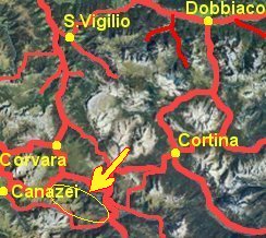
| Well
visible from: the whole upper valley of the Cordevole,
the Marmolada and the Fedaia lake, the
upper Avisio valley, the Pordoi, the
Pralongià, the Sella Group...
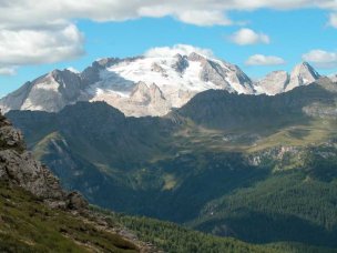
The Padon is the dark ridge beyond which the Marmolada
can be seen
(between us and the Padon there is the Cordevole valley
with Arabba;
between the Padon and the Marmolada, the Fedaia lake).
(Photo IlPalo - http://www.sassodiasiago.it/dal_sito_www_ilpalo_net.htm)
|
|
Excursions:
from
the
Castiglioni hut near the Fedaia lake
(m 2054) along the pathway named Vial del Pan, through
the Vial del Pan hut m 2436 to Baita Fregarola
hut m 2388, 2 hs.; to the Pordoi pass m 2239,
1/2 hs. Wide and continuous view over the Marmolada and
what remains of its glacier. Detour possible to porta
Vescovo hut, m 2516, from where a cable lift descends
to Arabba. From porta Vescovo, the difficult
and exposed Ferrata delle Trincee ("aided
climb of the Trenches"; war remains) brings
in about 3 hs. to Passo Padon hut m 2407, from
where an easy path brings back to the Fedaia
lake. |
 |